Log in
All resources
Create a design
402 Free Artworks of Details Of Old Maps
maps of paris from the david rumsey historical map collection
atlas des anciens plans de paris by imprimerie nationale, 1900 from the david rumsey historical map collection
atlas map
david rumsey historical map collection
maps by willem and johannes blaeu
baroque
18th-century maps of paris
map of paris by jouvin de rochefort (boutier 112)
turgot map of paris, david rumsey historical map collection
details of old maps of india
maps by willem and johannes blaeu
old maps of groningen (city)
maps of goa by linschoten
baroque
hamburg in topographia saxoniae inferioris (merian)
baroque
maps by willem and johannes blaeu
old maps of leiden
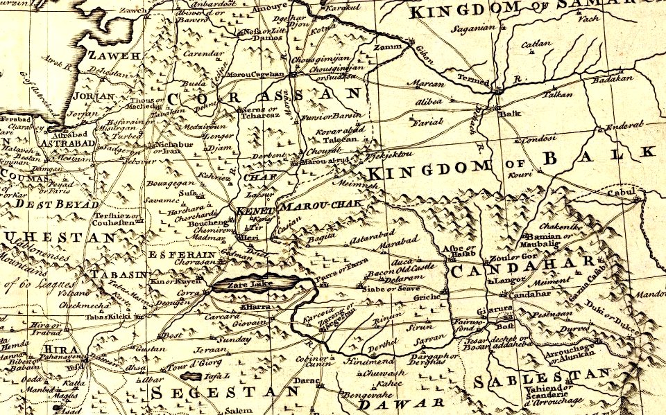
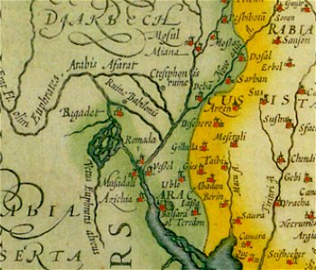
1747 persia map by emanuel bowen
details of old maps
maps of the caribbean by mercator-hondius
details of old maps
ancien couvent des dominicains (avignon)
cosmographia (1575) by sebastian münster
city gates in gouda
old maps of gouda
hendrik van langren map of south asia
1590s maps of iran
maps in the staats- und universitätsbibliothek hamburg
maps of hamburg-altstadt
claes jansz. visscher (ii)
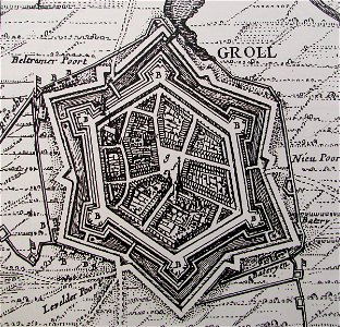
siege of groenlo 1627
hamburgische elbkarte von melchior lorichs
parts of old maps of hamburg
historic views of mainz
baroque
map of bruges by marcus gheeraerts (i)
old maps of sluis
old maps of veliky novgorod
maps of velikiy novgorod
hendrik van langren map of south asia
1590s maps of the levant
hendrik van langren map of south asia
renaissance
old maps of westphalia
sharp s
lithographs of paris
floor plans of paris
details of old maps of india
atlas minor
old maps of regions of france
pierre françois tardieu
maps of moers by johannes mercator
old maps of duisburg
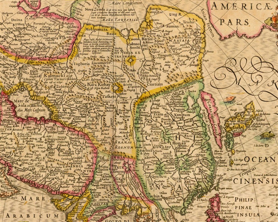
maps of asia by mercator-hondius
details of old maps
gardens in the vatican city
high renaissance
old maps of naples
mannerism
maps of paris from the david rumsey historical map collection
romanticism
siege of bredevoort 1597
old maps of bredevoort
viktoriastraße (berlin-lichterfelde)
parts of old maps of berlin
maps by willem and johannes blaeu
atlas van loon
grote of sint-bartholomeüskerk (schoonhoven)
old maps of schoonhoven
maps by willem and johannes blaeu
old maps of drenthe
1801 maps of germany
maps by john cary
ferrariae ducatus (galleria delle carte geografiche)
siege of mirandola (1510)
riga in the 17th century
old maps of riga
old submaps of paris 1er arrondissement
plans of the palais-royal
magni ducatus lithuaniae
details of old maps
prints by ambrogio brambilla
old maps of parma
atlas des anciens plans de paris by imprimerie nationale, 1900 from the david rumsey historical map collection
maps of paris from the david rumsey historical map collection
atlas des anciens plans de paris by imprimerie nationale, 1900 from the david rumsey historical map collection
maps of paris from the david rumsey historical map collection
atlas des anciens plans de paris by imprimerie nationale, 1900 from the david rumsey historical map collection
maps of paris from the david rumsey historical map collection
atlas des anciens plans de paris by imprimerie nationale, 1900 from the david rumsey historical map collection
maps of paris from the david rumsey historical map collection
atlas des anciens plans de paris by imprimerie nationale, 1900 from the david rumsey historical map collection
maps of paris from the david rumsey historical map collection
atlas des anciens plans de paris by imprimerie nationale, 1900 from the david rumsey historical map collection
maps of paris from the david rumsey historical map collection
maps by willem and johannes blaeu
old maps of gelderland
paintings by charles c. wood taylor
1830s history paintings
1777 maps of new york (state)
1777 maps of new jersey
maps of paris from the david rumsey historical map collection
baroque
maps of paris from the david rumsey historical map collection
baroque
1801 map of turkey in asia by john cary
1801 maps of the ottoman empire
palais des tuileries before 1659
baroque
maps by willem and johannes blaeu
old maps of friesland
maps by willem and johannes blaeu
old maps of friesland
maps by willem and johannes blaeu
old maps of friesland
jacques-nicolas bellin
1773 maps of africa
magni ducatus lithuaniae
history of ukmergė
panoramics in leipzig
adolf eltzner
engravings of cities in switzerland
engravings by matthäus merian
flandria illustrata
old maps of gistel
maps by willem and johannes blaeu
old maps of westphalia
native american history of virginia
17th-century maps of virginia
maps of paris from the david rumsey historical map collection
1774 in paris
turgot map of paris – derivative files
maison du temple (paris)
1609 works in north rhine-westphalia
abraham hogenberg
maps by pieter mortier
old maps of rovigo
maps by john cary
1799 maps
atlas des anciens plans de paris by imprimerie nationale, 1900 from the david rumsey historical map collection
maps of paris from the david rumsey historical map collection
atlas des anciens plans de paris by imprimerie nationale, 1900 from the david rumsey historical map collection
maps of paris from the david rumsey historical map collection
map of maastricht by willem and johannes blaeu (1649)
markt (maastricht)
14th-century illuminated manuscripts from spain
jong (ship)
atlas des anciens plans de paris by imprimerie nationale, 1900 from the david rumsey historical map collection
maps of paris from the david rumsey historical map collection
map of the german empire by louis stanislas d'arcy de la rochette
1780s maps of lithuania
1800s maps of egypt
maps by john cary
hamburgische elbkarte von melchior lorichs
parts of old maps of hamburg
1747 persia map by emanuel bowen
details of old maps
histoire universelle depuis le commencement du monde
maps of gulf of khambhat
histoire universelle depuis le commencement du monde
maps of gulf of khambhat
atlas des anciens plans de paris by imprimerie nationale, 1900 from the david rumsey historical map collection
maps of paris from the david rumsey historical map collection
prints by ambrogio brambilla
old maps of parma
18th-century maps of the mediterranean sea
1745 maps
maps of paris from the david rumsey historical map collection
baroque
maps of paris from the david rumsey historical map collection
baroque
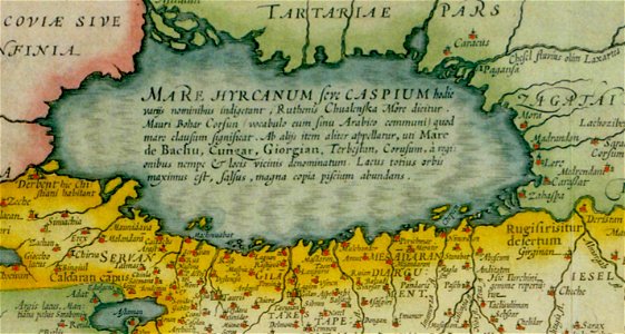
17th-century maps of the caspian sea
maps of persia by mercator-hondius
atlas des anciens plans de paris by imprimerie nationale, 1900 from the david rumsey historical map collection
maps of paris from the david rumsey historical map collection
atlas des anciens plans de paris by imprimerie nationale, 1900 from the david rumsey historical map collection
maps of paris from the david rumsey historical map collection
atlas des anciens plans de paris by imprimerie nationale, 1900 from the david rumsey historical map collection
maps of paris from the david rumsey historical map collection
atlas des anciens plans de paris by imprimerie nationale, 1900 from the david rumsey historical map collection
maps of paris from the david rumsey historical map collection
atlas des anciens plans de paris by imprimerie nationale, 1900 from the david rumsey historical map collection
maps of paris from the david rumsey historical map collection
atlas des anciens plans de paris by imprimerie nationale, 1900 from the david rumsey historical map collection
maps of paris from the david rumsey historical map collection
maps of persia by mercator-hondius
details of old maps
americae 1562 by diego gutiérrez and hieronymus cock
renaissance
english-language maps
1747 maps of asia
atlas des anciens plans de paris by imprimerie nationale, 1900 from the david rumsey historical map collection
maps of paris from the david rumsey historical map collection
maps of paris from the david rumsey historical map collection
romanticism
atlas des anciens plans de paris by imprimerie nationale, 1900 from the david rumsey historical map collection
maps of paris from the david rumsey historical map collection
maps of paris from the david rumsey historical map collection
romanticism
atlas des anciens plans de paris by imprimerie nationale, 1900 from the david rumsey historical map collection
maps of paris from the david rumsey historical map collection
atlas des anciens plans de paris by imprimerie nationale, 1900 from the david rumsey historical map collection
maps of paris from the david rumsey historical map collection
haarlem nautz map 1822-1829
old maps of haarlem
manual of the corporation of the city of new york (1862)
maps from valentine's manual
maps in the library of congress
old maps of france
201 - 300 of 402
Next page
/ 5